This report covers crop conditions for maize, wheat, soybean and rice between the months of October 2022 to January 2023 in Nigeria, when the country entered the dry season. Rice, millet, and sorghum were harvested in November and December. Harvest of second season maize was completed in January.
Rainfall recorded for the country during this period was -32% below the 15YA. The temperature recorded was -0.9oC below the 15YA. Solar radiation did not deviate from the 15YA. As a result of these factors, the BIOMSS also fell below the 15YA by -13%. The CALF was above the 15YA at 4% while the observed maximum vegetation condition index (VCI) was 0.89.
The crop condition development graph based on NDVI shows that the NDVI was mostly below the 5YA throughout the reporting period until January, when it levelled off and approached the 5YA. The Crop Production Index (CPI) for the country was at 1 which indicates normal conditions.
As shown in the spatial NDVI profiles and distribution map, 48.2% of the country covering the middle belt and parts of the north were mostly below the 15YA throughout the period, while 32% covering the northern part of the country were above the 15YA. It was observed that a portion of 7.8% and 7.4% dropped far below the 15YA in early October, but by mid-October, was back to near the average for the rest of the monitoring period. The same applies to a portion of 4.6% predominant along the Niger and Benue River as well as the southern part of the country which also fell far below the average in October, but began to rise towards the average in December, but by January, it rose slightly above average. Most likely, the sharp negative departures were artifacts, caused by cloud cover in the satellite images. Overall, the rainfall deficit caused favorable conditions for harvest, but it may have negatively impacted the yield of some late sown crops. Conditions can be assessed as close to normal.
Regional Analysis
The analysis focuses on the nine agro-ecological zones in the country transiting from North to South, i.e., Sahel Savannah(153), Sudan Savannah(154), Guinea Savannah(148), Derived Savannah(146), Jos Plateau(149), Mountain Forest(152), Lowland Rainforest(150), Freshwater Swamp Forest(147) and Mangroove Forest(151).
The Sahel Savanah is found in the north-eastern part of the country, followed by the Sudan Savanah which stretches across the entire northern region. The Guinea savannah is the largest, which is a transition between the Sudan Savanah and the Derived Savanah, covering a large portion of the central part the country. The Derived Savanah, Fresh Water Swamp, Rain Forest and Mangrove Forest are all located in the southern part of the country. While the Jos Plateau and the Mountain Forest are also located in the central part of the country.
In the Sahel Savanah zone, the agro-climatic conditions showed that the region experienced the highest decrease in rainfall at -93% and the average temperature was -1.4°C below the 15YA. The radiation decreased by -1%. The drastic decrease in rainfall caused a reduction in BIOMSS by -6%. However, CALF in this area was 6% above the 5YA and the maximum VCI was 0.97.
In the Sudan Savannah, the agro-climatic condition also showed a drastic decline in rainfall at -55% and the average temperature was -1.2°C below the 15YA. The radiation decreased by -1%. And as expected, there was also a significant decrease in the BIOMSS which stood at -17%. However, CALF increased by 7% and the maximum VCI was 0.91.
The Guinea savannah zone, which is predominantly located in the central region also recorded a high decrease in rainfall by -52%, temperature was at -1°C below the 15YA, while radiation was at 0%, and BIOMSS dropped by -13%. The CALF was lower by -1% and the maximum VCI was 0.84.
The Mountain Forest which covers a very small portion in the central part of the country, recorded a rainfall of -47%, temperature was at -1.2°C, while radiation increased to 1%, and BIOMSS dropped down to -20%. The CALF was on average and the maximum VCI was 0.88.
The Jos Plateau which is also located in the central region recorded rainfall of -65%, temperature was lower than the 15YA at -0.7°C, while there was no change in radiation (0%), and BIOMSS was down to -18%. The CALF was unchanged and the maximum VCI was 0.89.
The Derived Savanah region recorded rainfall of -32%, the temperature was at -0.5°C, the radiation was slightly above the 15YA at 1% with a recorded BIOMSS of -11% and a CALF of -1%. The maximum VCI was at 0.86.
The Lowland Rain Forest also recorded a decrease in rainfall at -22%, and temperature was at -0.3°C. The radiation was at 0% and the BIOMSS was also low at -12%. The CALF was levelled on the 5YA at 0% and the maximum VCI was 0.89.
The Fresh Water Swamp Forest is located in the southern region of the country and does not cover a large area. Rainfall in this area was also at -22%, temperature was -1°C, while radiation fell to -1%, and BIOMSS dropped down to -10%. The CALF was lower by -1% and the maximum VCI was 0.86.
The Mangroove Forest, also located in the southern region of the country recorded rainfall of -16%, temperature of -0.2°C, a decreased radiation of -1%, and BIOMSS of -8%. With CALF on the average at 0% and the maximum VCI was 0.85.
The Crop Production Index (CPI) recorded for most of the agro ecological zones was at 1 which indicates normal production index, except for the Fresh Water Swamp Forest, Mangroove Forest and Mountain Forest.
Figures 3.34 Nigeria's crop condition, October 2022-January 2023

(a). Phenology of major crops
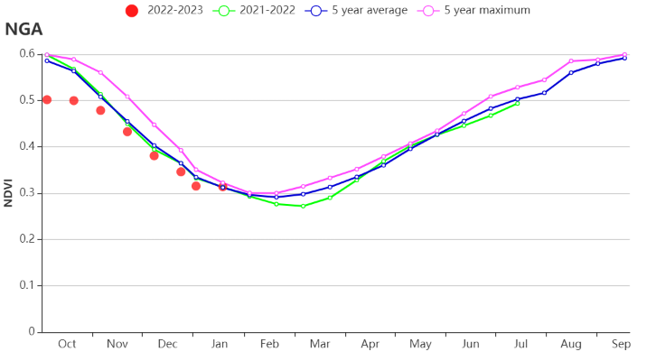
(b) Crop condition development graph based on NDVI
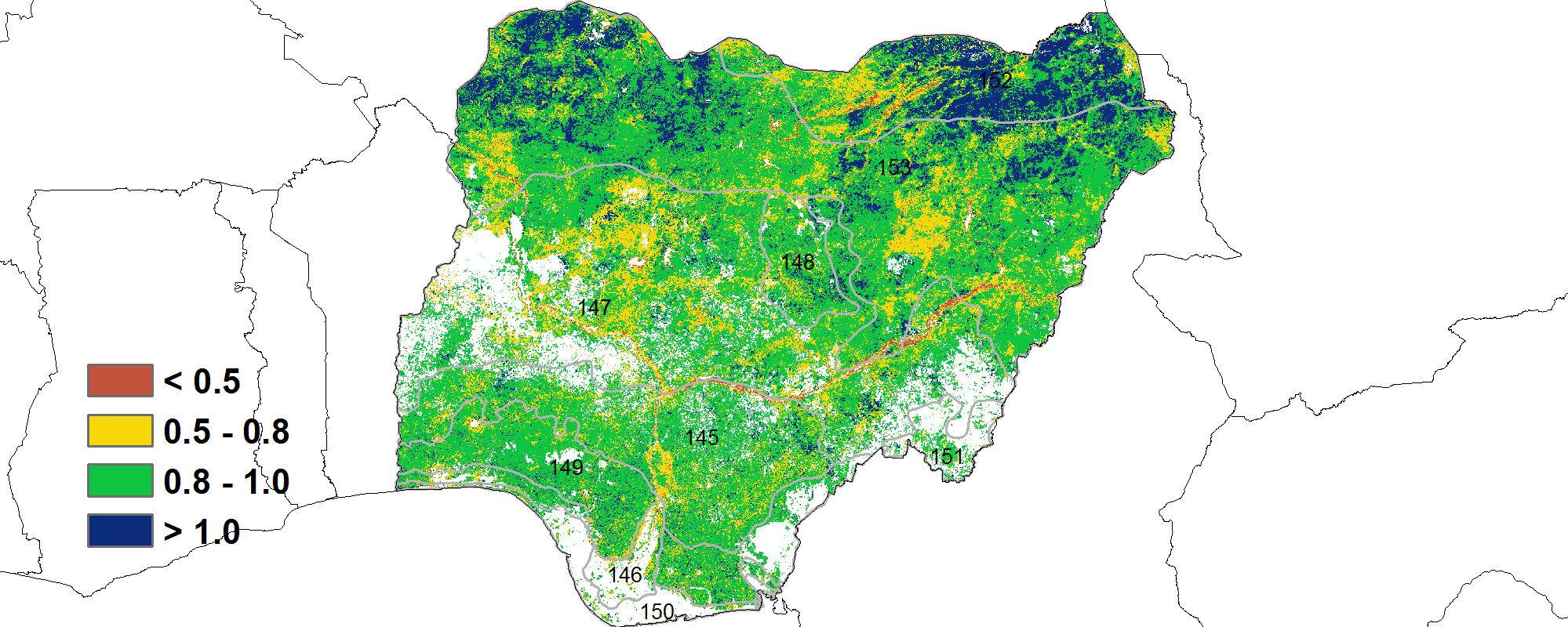
(c) Maximum VCI
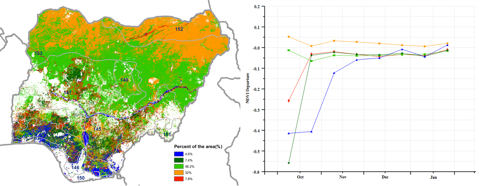
(d) Spatial NDVI patterns compared to 5YA (e) NDVI profiles
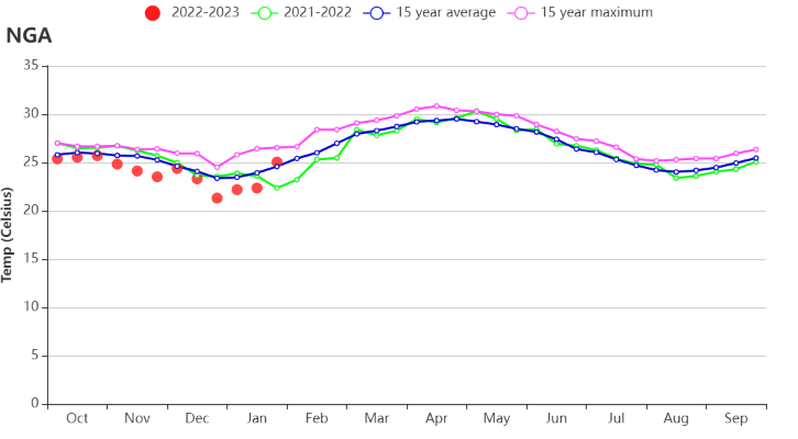
(f) Time series temperature profile
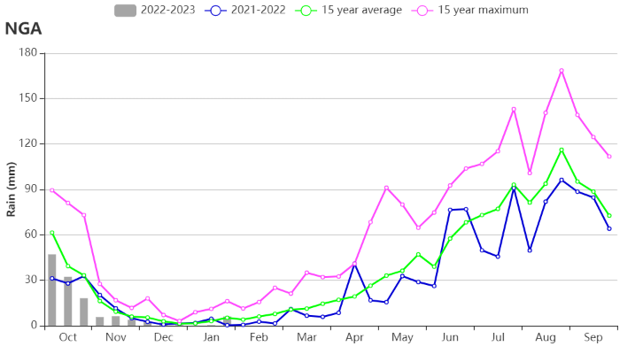
(g) Time series rainfall profile


(h) Crop condition development graph based on NDVI(Left:Derived Savannah (146), Right: Freshwater Swamp Forest(147))

![]()
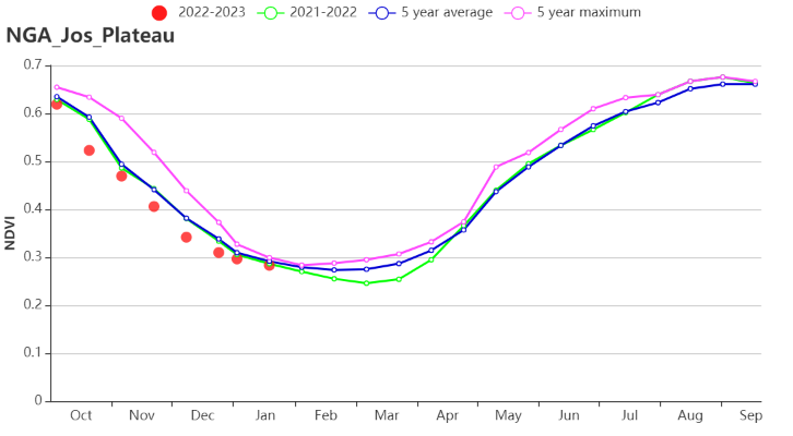
(i) Crop condition development graph based on NDVI(Left:Guinea Savannah (148), Right: Jos Plateau(149))
![]()
![]()
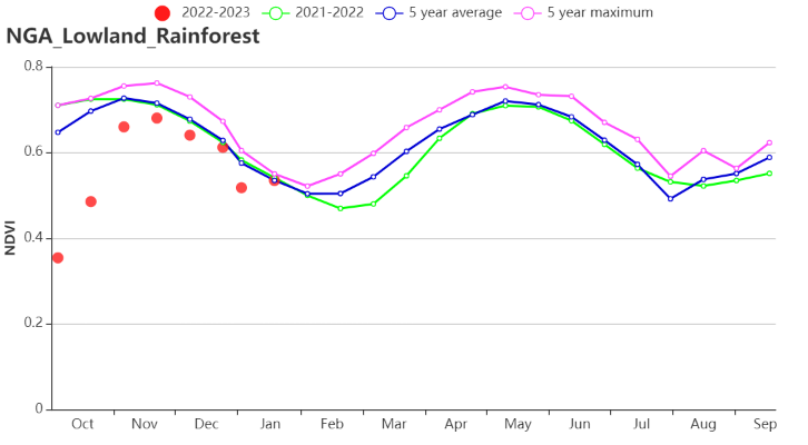
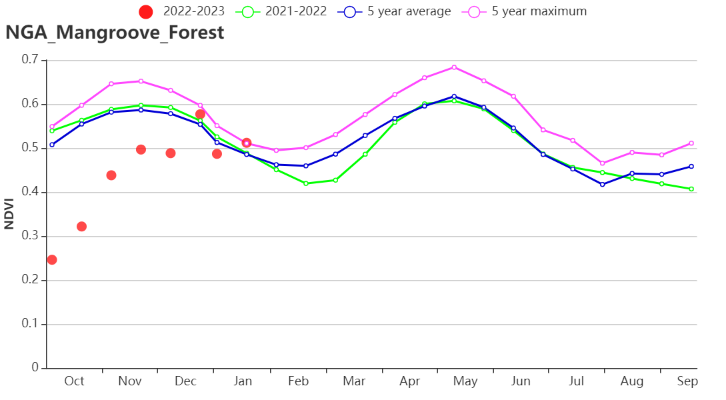
(j) Crop condition development graph based on NDVI(Left:Lowland Rainforest (150), Right: Mangroove Forest (151))


(k) Crop condition development graph based on NDVI(Left:Mountain Forest(152), Right: Sahel Savannah(153))

(l) Crop condition development graph based on NDVI(Sudan Savannah(154))
Table 3.60 Nigeria's agro-climatic indicators by sub-national regions, current season's values and departure from 15YA. October 2022-January 2023
| Region | RAIN | TEMP | RADPAR | BIOMSS | ||||
| Current(mm) | Departure from 15YA(%) | Current(°C) | Departure from 15YA(°C) | Current(MJ/m2) | Departure from 15YA(%) | Current(gDM/m2) | Departure from 15YA(%) | |
| Derived Savannah | 159 | -32 | 25.5 | -0.5 | 1221 | 1 | 645 | -11 |
| Freshwater Swamp Forest | 467 | -22 | 26.0 | -0.1 | 1169 | -1 | 1011 | -10 |
| Guinea Savannah | 48 | -52 | 23.9 | -1.0 | 1280 | 0 | 496 | -13 |
| Jos Plateau | 33 | -65 | 21.1 | -0.7 | 1324 | 0 | 435 | -18 |
| Lowland Rainforest | 381 | -22 | 25.4 | -0.3 | 1189 | 0 | 854 | -12 |
| Mangroove Forest | 662 | -16 | 25.8 | -0.2 | 1187 | -1 | 1137 | -8 |
| Montane Forest | 184 | -47 | 20.2 | -1.2 | 1323 | 1 | 571 | -20 |
| Sahel Savannah | 1 | -93 | 22.8 | -1.4 | 1219 | -1 | 355 | -6 |
| Sudan Savannah | 23 | -55 | 23.0 | -1.2 | 1264 | -1 | 385 | -17 |
Table 3.61 Nigeria's agro-climatic indicators by sub-national regions, current season’s values and departure from 5YA. October 2022-January 2023
| Region | CALF | Maximum VCI | |
| Current(%) | Departure from 5YA(%) | Current | |
| Derived Savannah | 98 | -1 | 0.86 |
| Freshwater Swamp Forest | 96 | -1 | 0.86 |
| Guinea Savannah | 97 | -1 | 0.84 |
| Jos Plateau | 99 | 0 | 0.89 |
| Lowland Rainforest | 99 | 0 | 0.89 |
| Mangroove Forest | 93 | 0 | 0.85 |
| Montane Forest | 100 | 0 | 0.88 |
| Sahel Savannah | 57 | 60 | 0.97 |
| Sudan Savannah | 88 | 7 | 0.91 |
